When our "islamorealism" ads went up (in response to a vicious anti-Israel ad that was running), Mayor Mayor Peter Swiderski (mayor@hastingsgov.org) and the Board of Trustees sent a letter to the entire village asking residents to express their outrage to Joseph Lhota, MTA chairman,concerning our islamorealism ad (below, the ad updated as the number of deadly Islamic attacks increased an additonal 500 acts of jihad since early September.)fascinating. the new map responds to the allegation that the land was mostly state owned and then assumes ownership based on illegal homes... then further ignores actual data concerning Arab property. It's a fucking lie is what it is when they merely show Jewish housing.
Another vicious anti-semitic campaing is now running on NYC Metro North (see below). Mayor Peter Swiderski, the Board of Trustees, and Greenburgh Town Supervisor Paul Feiner (who actually protested our ad) have been silent (subdued as Islamic supremacists demand) in response to the new defamatory campaign. As has the media (remember the furor?)
Where is the media ad furor?
I sent the following email to Mayor Swiderski and the Board of Trustees (and cc'ed the NY Times and the NY Post) -- still waiting for a request for comment:
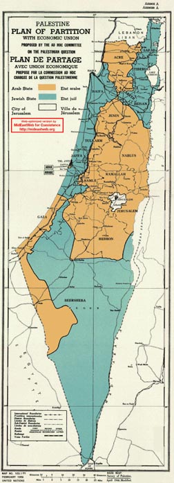
And just for knowing, this is a map of what the Jewish people were promised at San Remo (international law) and in the Balfour agreement. 'Will you be protesting this Jewish blood libel (the second anti-Israel ad campaign at Metro) or is your moral indignation and outrage employed only on behalf of slaughtering jihadists?
To measure the extent of American commitment to the National Home at the beginning, we may quote from the terminology of the time: "RES. 52: Expressing satisfaction at the re-creation of Palestine as the national home of the Jewish race" (House Committee on Foreign Affairs). "Resolved by the Senate and House of Representatives of the United States of America in Congress assembled, that the United States of America favors the establishment in Palestine of a national home for the Jewish people..." (1922).Israel is a fraction of what was originally agreed to and the enemies are working to shrink it until it disappears altogether. Here is the San Remo map of what Israel ("Palestine") was supposed to be (more here):
Arab Riots and Jewish immigration - In the spring of 1920, spring of 1921 and summer of 1929, Arab nationalists opposed to the Balfour declaration, the mandate and the Jewish National Home, instigated riots and pogroms against Jews in Jerusalem, Hebron, Jaffa and Haifa.And so there are two states - Israel and Jordan.
Here is the new anti-Israel ad runing on NYC's Metro North:
At Metro-North Railway, New Map, More Distortions Snapshot blogHenry Clifford, who earlier bankrolled distorted maps about Israel and the Palestine Mandate at Metro-North Railway stations in New York, this month has come up with a new one. Well, actually, he pulled it from the Web site of PASSIA:
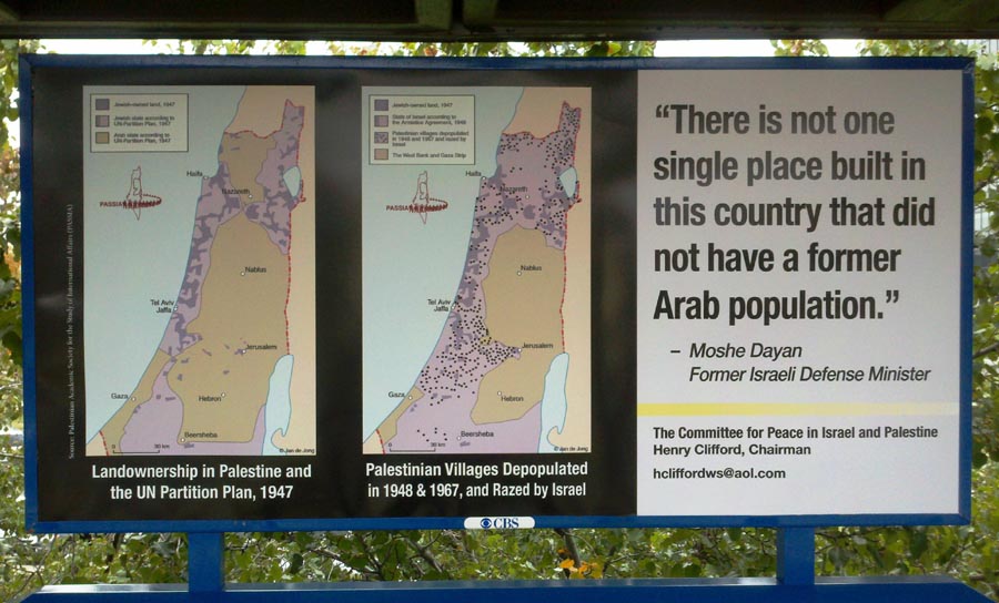
The map on the left is a huge manipulation for multiple reasons. First, though its title refers to "Land ownership" and it shows pockets of "Jewish-owned land" in 1947, the equivalent Arab-owned land is not identified. Instead, in an apples-versus-oranges misleading comparison, the Jewish-owned land is juxtaposed against land designated for an Arab state according to the U.N. Partition Plan.
So why doesn't Clifford show us the Arab-owned land? If he did, commuters would see that the amount of privately-owned Arab land was nearly equivalent to privately-owned Jewish land. As previously noted by CAMERA:
During the Mandate, the British carried out detailed land surveys, marking off who owned what, and according to figures in the British Survey of Palestine, published in 1946 and republished by the PLO-affiliated Institute for Palestine Studies, at least 65 percent of the country was state land, and probably much more than that. Jews owned 8.6 percent of the land and Arabs owned 28.6 percent. But the Arab total included Bedouin grazing land (8.4 percent) and waste land (13.4 percent), neither of which was legally ownable according to the prevailing Turkish and British land laws. Not counting Bedouin grazing land and waste land, Arab owned land totaled only 6.8 percent.Second, Clifford's map falsely designates Jerusalem as part of the land slated to go to an Arab state under the 1947 partition plan. In reality, as illustrated by the U.N. map below, the plan called for Jerusalem and its suburbs to become an international zone:
Moreover, under the partition plan, Jaffa was supposed to have been part of the Arab state, but Clifford's ad wrongly indicates it was to be part of the Jewish state.
As for the Moshe Dayan quote, CAMERA called Clifford out several months ago for truncating the statement, cutting out Dayan's assertion that Jews purchased much of the land: "In a considerable number of places, we purchased the land from Arabs and set up Jewish villages where there had once been Arab villages."
But Clifford, the one man show called the Committee for Peace in Israel and Palestine, will not be deterred by the facts. Like the commuter rail, he barrels on full steam ahead, running over any facts along the way.

Featured Post
(no nuance to HillaryClinton's views) she made it clear in her recent book
IN THE MIDDLE EAST CHAPTER OF HER BOOK MS CLINTON MAKES STATEMENTS THAT AT BEST COULD BE CONSIDERED INSENSITIVE TO ISRAEL, OR AT WORST THA...
